Home
Hungary
Cardinal József Mindszenty
1956 Hungarian Revolution (My Story)
(My Eyewitness story of our Freedomfight
and Resistance against the Soviet Invasion)
50th Anniversary of our Freedomfight
My Travel and Photos Pages
Africa
America - North
America - Central
America - South
Asia
Australia
Oceania
My China pages directory
Beijing or Peking
Beijing Buses
Beijing - Forbidden City
Beijing - Prince Gong Palace
Beijing - Summer Palace
Great Wall of China
Guangzhou or Canton
Guangzhou Buses
Guangzhou trains
Hong Kong
Hong Kong Airport
Hong Kong Buses
Hong Kong - Lantau Island
Kashgar or Kashi
Kashgar Buses
Kashgar Sunday Market
Macau
Ming Dynasty Tombs
Peking Man's Caves/Zhoukoudian
Shanghai
Shanghai Buses
Shanghai Maglev / Transrapid
Shanghai Metro
Shenzhen
Shenzhen Buses
Tibet
Tibet - Lhasa
Tibet - Lhasa Monasteries
Tibet - Lhasa - Potala
Turpan or Tulufan
Turpan - Amin Mosque
Turpan - Astana Graves
Turpan - Bezeklik Caves
Turpan - Crescent Moon Lake
Turpan - Dunhuang Caves
Turpan - Echoing-Sand Mountain
Turpan - Ediqut Ruins
Turpan - Emin Minaret
Turpan - Flaming Mountains
Turpan - Gaochang Ruins
Turpan - Grape Valley
Turpan - Green Mosque
Turpan - Jesus Sutras
Turpan - Jiaohe Ruins
Turpan - Karez System
Turpan - Maza Village
Turpan - Mogao Caves
Urumchi or Urumuchi
Xian
Xian Buses
Xian - Hua Qing Pool
Xian - Silk Factory
Xian - Silk Road Monuments
Xian - Terracotta Factory
Xian - Terracotta Army Museum
Yanan
Yanan Buses
Yanan Cave Dwellings
|

China facts & history in brief
 My China pages directory
Map of China
Qanat
Excerpted from Wikipedia, the free encyclopedia
A qanat (Arabic) or kareez (Persian) or karez
(Turpan) is a water management system used to provide
a reliable supply of water to human settlements or for
irrigation in hot, arid and semi-arid climates.
The widespread distribution of qanat known in different
places in their local names has confounded the question
of its origin, but the earliest evidence of this technology
dates back to ancient Persia, and spread west during the
Arab Muslim conquests, to the Iberian peninsula,
southern Italy and North Africa.
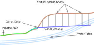
Qanats are constructed as a series of well-like
vertical shafts, connected by gently sloping tunnels.
This technique taps into subterranean water in a manner
that efficiently delivers large quantities of water
to the surface without need for pumping.
The water drains relying on gravity, with the
destination lower than the source,
which is typically an upland aquifer.
This allows water to be transported long distances
in hot dry climates without losing a large
proportion of the source water
to seepage and evaporation.
It is very common in the construction of a qanat
for the water source to be found below ground at
the foot of a range of foothills of mountains,
where the water table is closest to the surface.
From this point, the slope of the qanat is maintained
closer to level than the surface above, until the
water finally flows out of the qanat above ground.
To reach an underground aquifer qanats
must often be of extreme length.
The qanat technology was used most extensively in
areas with the an absence of larger rivers with
year-round flows sufficient to support irrigation.
Proximity of potentially fertile areas to
precipitation-rich mountains or mountain ranges.
Arid climate with its high surface evaporation
rates so that surface reservoirs and
canals would result in high losses.
An aquifer at the potentially fertile area which
is too deep for convenient use of simple wells.
The investment and organization required by the
construction and the maintenance of a qanat is
typically provided by local merchants
or landowners in small groups.
In the middle of the twentieth century, it is
estimated that approximately 50,000 qanats were
in use in Iran, each commissioned
and maintained by local users.
The qanat system has the advantage of being
relatively immune to natural disasters
(earthquakes, floods.) and human
destruction in war.
Further it is relatively insensitive to the
levels of precipitation; a qanat typically
delivers a relatively constant flow with only
gradual variations from wet to dry years.
A typical town or city in Iran and elsewhere
where the qanat is used has more than one qanat.
Fields and gardens are located both over the qanats
a short distance before they emerge from the ground
and after the surface outlet.
Water from the qanats defines both the social regions
in the city and the layout of the city.
The water is freshest, cleanest, and coolest in the
upper reaches and more prosperous people live at
the outlet or immediately upstream of the outlet.
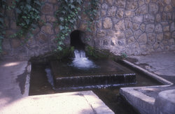
A kariz (a small qanat) surfacing in Tehran.
When the qanat is still below grade, the
water is drawn to the surface via Ater-wells
or animal driven Persian wells.
Private subterranean reservoirs could
supply houses and buildings for domestic use
and garden irrigation as well.
Air flow from the qanat is used to cool
an underground summer room (shabestan) found
in many older houses and buildings.
Qanat or karez construction
Downstream of the outlet, the water runs through
surface canals called jubs (jubs) which run
downhill, with lateral branches to carry water to
the neighborhood, gardens and fields.
The streets normally parallel the jubs
and their lateral branches.
As a result, the cities and towns are
oriented consistent with the gradient
of the land; what is sometimes viewed
as chaotic to the western eye is a
practical response to efficient water
distribution over varying terrain.
The lower reaches of the canals are less desirable
for both residences and agriculture.
The water grows progressively more
polluted as it passes downstream.
In dry years the lower reaches are the
most likely to see substantial
reductions in flow.
Traditionally qanats are built by a group
of skilled laborers, muqannis, with hand labor.
The profession historically paid well and was
typically handed down from father to son.
The critical, initial step in qanat construction
is identification of an appropriate water source.
The search begins at the point where the alluvial fan
meets the mountains or foothills; water is more abundant
in the mountains because of orographic lifting and
excavation in the alluvial fan is relatively easy.
The muqannis follow the track of the main water courses
coming from the mountains or foothills to identify
evidence of subsurface water such as
deep-rooted vegetation or seasonal seeps.
A trial well is then dug to determine the location
of the water table and determine whether a sufficient
flow is available to justify construction.
If these prerequisites are met, then
the route is laid out aboveground.
Equipment must be assembled.
The equipment is straightforward: containers
(usually leather bags), ropes, reels to raise
the container to the surface at the shaft head,
hatchets and shovels for excavation, lights,
spirit levels or plumb bobs and string.
Depending upon the soil type, qanat liners
(usually fired clay hoops) may also be required.
Although the construction methods are simple,
the construction of a qanat requires a detailed understanding
of subterranean geology and a degree
of engineering sophistication.
The gradient of the qanat must be carefully
controlled-too shallow a gradient yields no flow -
too steep a gradient will result in excessive
erosion, collapsing the qanat.
And misreading the soil conditions leads to collapses
which at best require extensive rework and,
at worst, can be fatal for the crew.
Construction of a qanat is usually performed
by a crew of 3-4 muqannis.
For a shallow qanat, one worker typically digs the
horizontal shaft, one raises the excavated earth
from the shaft and one distributes the
excavated earth at the top.
The crew typically begins from the destination to
which the water will be delivered into the soil
and works toward the source (the test well).
Vertical shafts are excavated along the route,
separated at a distance of 20-35 m.
The separation of the shafts is a balance between
the amount of work required to excavate them and
the amount of effort required to excavate the space
between them, as well as the
ultimate maintenance effort.
In general, the shallower the qanat, the
closer the vertical shafts.
If the qanat is long, excavation may
begin from both ends at once.
Tributary channels are sometimes also
constructed to supplement the water flow.
Most qanats in Iran run less than 5 km.
The overall length of the qanat often runs up to 16 km,
while some have been measured at
~70 km in length near Kerman.
The vertical shafts usually range from 20 to 200 meters
in depth, although in Iran qanats in the province of
Khorasan have been recorded with
vertical shafts of up to 275 m.
The vertical shafts support construction and maintenance
of the underground channel as well as air interchange.
Deep shafts require intermediate platforms to
simplify the process of removing spoils.
The qanat's water-carrying channel is 50-100
cm wide and 90-150 cm high.
The channel must have a sufficient downward slope
that water flows easily.
However the downward gradient must not be so great
as to create conditions under which the water
transitions between supercritical and subcritical
flow; if this occurs, the waves which are established
result in severe erosion and can
damage or destroy the qanat.
In shorter qanats the downward gradient varies between
1:1000 and 1:1500, while in longer qanats
it may be almost horizontal.
Such precision is routinely obtained with
a spirit level and string.
In cases where the gradient is steeper, underground
waterfalls may be constructed with appropriate design
features (usually linings) to absorb the
energy with minimal erosion.
In some cases the water power has been
harnessed to drive underground mills.
If it is not possible to bring the outlet of the
qanat out near the settlement, it is necessary to
run a jub or canal overgound.
This is avoided when possible to limit pollution,
warming and water loss due to evaporation.
The construction speed depends on the depth.
At 20 meters depth, a crew of 4 people can excavate
a horizontal length of 40 meters per day.
When the vertical shaft reaches 40 meters, they can
only excavate 20 meters horizontally per day and at
60 meters in depth this drops below
5 horizontal meters per day.
Deep, long qanats (which many are) require years
and even decades to construct.
The excavated material is usually transported by
means of leather bags up the vertical shafts.
It is mounded around the vertical shaft exit,
providing a barrier that prevents windblown or
rain driven debris from entering the shafts.
From the air, these shafts look like
a string of bomb craters.
The vertical shafts may be covered to
minimize in-blown sand.
The channels of qanats must be periodically
inspected for erosion or cave-ins, cleaned
of sand and mud and otherwise repaired.
Air flow must be assured before
entry for human safety.
The value of a qanat is directly related to the
quality, volume and regularity of the water flow.
Much of the population of Iran historically depended
upon the water from qanats; the areas of population
corresponded closely to the areas
where qanats are possible.
Although a qanat was expensive to construct, its long-term
value to the community, and therefore to the group who
invested in building and maintaining it, was substantial.
Qanats were frequently split into an underground distribution
network of smaller canals called kariz
when reaching a major city.
Like Qanats, these smaller canals were below
ground to avoid contamination.
Qanats in practical application
China
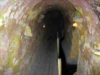
Karez gallery near Turpan
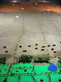
Model of karez well system (Turfan Water Museum)
An oasis at Turpan in the deserts of northwestern China
uses water provided by qanat (locally called karez).
Turfan has long been the center of a fertile oasis and an
important trade center along the Silk Road's northern route,
at which time it was adjacent to the kingdoms
of Korla and Karashahr to the southwest.
The historical record of the karez system
extends back to the Han Dynasty.
The Turfan Water Museum is a Protected Area because of the
importance of the local karez
system to the history of the area.
The number of karez systems in the area is slightly
below 1,000 and the total length of the
canals is about 5,000 kilometers in length.

For a more information about
Qanat see Wikipedia, the free encyclopedia
This page was retrieved and condensed from
(http://en.wikipedia.org/wiki/Qanat)
see Wikipedia, the free encyclopedia, November 2007.
All text is available under the terms of the
GNU Free Documentation License
(see
Copyrights for details).
About Wikipedia
Disclaimers
This information was correct in November 2007. E. & O.E.

Hui Chin and I joined a conducted bus tour
from Urumchi to visit Turpan.
It was a very interesting trip and full of drama, as
there was many interesting places to visit and there
was also a number of arguments
on the bus about the tickets and
sights to be visited, the sitting arrangements on the
bus and also about the food and the quality and hygene
standard of the restaurants we have visited.
To cap it all of, my camera's battery ran flat, half
way through, our spare battery and another camera sitting
safely back at the hotel in Urumchi (laughing at our
misfortune), but a few weeks later I had even worst news,
when, after returning home, I found out that two of my
new 2Gigabyte SD memory cards, although seemed to work
perfectly at the time, have invisible pictures on them.
The pictures seem to exist alright,
with all around the 200 plus kilobyte
properties and showing as jpeg pictures, but can't be viewed.
I have lost some very interesting, unusual and irreplacable
pictures of Turpan, Urumchi, Bishkek in Kyrgizstan and pictures
of the countrysides of Kyrgizstan and Kazakstan.
____________o______O_______o____________
Now altough we were there and had our visual and phisical
experiences, I have to take advantage of using Wikipedia,
the free encyclopedia's
resources with our greatful thanks. Author.
____________o______O_______o____________
I would like to mention a few things, that was mentioned to us
during our visit to Turpan, but I do not find any mention on
the pages and articles I read before
putting this page together.
Turpan is sited in a basin (Turfan Depression),
at the second deepest hole after the Dead Sea - under
sea level.
(328ft. below sea level).
Turpan is one of the hottest place on earth, due to its
desert location and relative altitude.
Turpan also one of the driest place on earth again due
to it's location and altitude. (This last two points
make it ideal place to grow grapes and other fruit with
the Karez (water) System's help.
Some of Turpan's listed attractions may be 40+ kilometres
away, normally they still will be listed
as Turpan's attraction.
On the way to Turpan from Urumchi our bus stopped at a
fortress, as I lost the many photos I have taken of this
place - as I have explained above, now I can't find any
reference or mention of the place - can somebody help me, please?
Author.
The Karez System as operated in Turpan
|