|
|
|
|
|
|
|
|
|
|
|
|
Venezuela
Other pages in my Venezuela series.
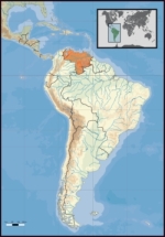
 Location of Venezuela.
The country comprises a continental mainland and numerous islands located off the Venezuelan coastline in the Caribbean Sea. Venezuela bordered by Guyana to the east, Brazil to the south, and Colombia to the west. Trinidad and Tobago, Grenada, St. Lucia, Barbados, Curacao, Bonaire, Aruba, Saint Vincent and the Grenadines and the Leeward Antilles lie just north, off the Venezuelan coast. Its size is 916,445 km² with an estimated population of 26,414,816. Capital is Caracas. Falling within the tropics, Venezuela sits close to the equator, in the Southern Hemisphere. The flag colours are yellow, blue and red, in that order. The yellow stands for land wealth, the blue for courage, and the red for independence from Spain. A former Spanish colony, which has been an independent republic since 1821, Venezuela holds territorial disputes with Guyana, largely concerning the Essequibo area, and with Colombia concerning the Gulf of Venezuela. In 1895, after the dispute over the Guyana border flared up, it was submitted to a neutral commission, which in 1899 decided mostly in Guyana's favour. Today, the Bolivarian Republic of Venezuela is known widely for its petroleum industry, the environmental diversity of its territory, and its natural features. Venezuela is considered to be among the world's 18 most biodiverse countries, featuring diverse wildlife in a variety of protected habitats. Venezuela is among the most urbanised countries in Latin America, the vast majority of Venezuelans live in the cities of the north, especially in the capital Caracas which is also the largest city. Other major cities include Maracaibo, Valencia, Maracay, Barquisimeto and Ciudad Guayana. Venezuela: - Co-ordinates: 10°30'N 66°58'W Capital: (and largest city) Caracas Official language: Spanish Ethnic groups: 70% Mestizo, 20% White, 5% Amerindian, 5% others (Africans, Arabs, Asians) Demonym: Venezuelan Government: Federal presidential republic - President Hugo Chávez Frias (May 2009) - Vice president Ramón Carrizales(May 2009) Independence: - from Spain July 5, 1811 - from Gran Colombia January 13, 1830 - Recognized March 30, 1845 Area: - Total 916,445 km² (33rd) 353,841 sq mi - Water (%) 0.32 Population: - February 2008 estimate 28,199,825 (40th) - 2001 census 23,054,985 - Density 30.2/km² (173rd) 77/sq mi GDP: (PPP) 2008 estimate - Total $358.623 billion - Per capita $12,785 Gini: (2007) 42.2 (high) HDI: (2007) ? 0.826 (high) (61st) Currency: Bolivar fuerte (VEF) Time zone: UTC-4:30 Drives on the: right Internet TLD: .ve Calling code: 58 * The "Bolivarian Republic of Venezuela" has been the full official title since the adoption of the new Constitution of 1999, when the state was renamed in honour of Simón Bolivar. * The Constitution also recognizes all indigenous languages spoken in the country. * Area totals include only Venezuelan-administered territory. * On January 1, 2008 a new bolivar, the bolivar fuerte (ISO 4217 code VEF), worth 1,000 VEB, was introduced. Geography Venezuela's mainland rests on the South American Plate; With 2,800 kilometres (1,740 mi) of coastline, Venezuela is home to a wide variety of landscapes. The extreme northeastern extensions of the Andes reach into Venezuela's northwest and continue along the northern Caribbean coast. Pico Bolivar, the nation's highest point at 4,979 metres (16,335 ft), lies in this region. The country's centre is characterized by the llanos, extensive plains that stretch from the Colombian border in the far west to the Orinoco River delta in the east. To the south, the dissected Guiana Highlands is home to the northern fringes of the Amazon Basin and Angel Falls, the world's highest waterfall. The Orinoco, with its rich alluvial soils, binds the largest and most important river system of the country; it originates in one of the largest watersheds in Latin America. The Caroni and the Apure are other major rivers. The country can be further divided into ten geographical areas, some corresponding to climatic and biogeographical regions. In the north are the Venezuelan Andes and the Coro region, a mountainous tract in the northwest, is home to several sierras and valleys. East of it are lowlands abutting Lake Maracaibo and the Gulf of Venezuela. The Central Range runs parallel to the coast and includes the hills surrounding Caracas; the Eastern Range, separated from the Central Range by the Gulf of Cariaco, covers all of Sucre and northern Monagas. The Llanos region comprises a third of the country's area north of the Orinoco River. South of it lies the Guiana Shield, a massive Precambrian geological formation featuring tepuis, mysterious table-like mountains. The Insular Region includes all of Venezuela's island possessions: Nueva Esparta and the various Federal Dependencies. The Deltaic System, which forms a triangle covering Delta Amacuro, projects northeast into the Atlantic Ocean.
Other pages in my Venezuela series.
Site Index Back to Top Photos Index Thanks for coming, I hope you
have enjoyed it, will recommend
it to your friends, and will come
back later to see my site developing
and expanding.
|