|
|
|
|
|
|
|
|
|
|
|
|
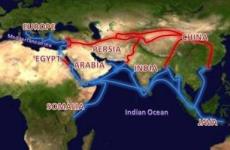
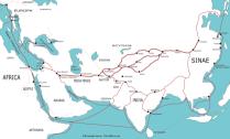
Silk Road - Silk RouteEurope - AsiaThe Silk Road, or Silk Route, is a series of trade and cultural transmission routes that were central to cultural interaction through regions of the Asian continent connecting East and West by linking traders, merchants, pilgrims, monks, soldiers, nomads and urban dwellers from China to the Mediterranean Sea during various periods of time. Geographically, the Silk Road is an interconnected series of ancient trade routes between Chang'an (today's Xi'an) in China, with Asia Minor and the subcontinent, and Rome, and helped to lay the foundations for the modern world. The first person who used the term "Seidenstraße" or "Silk Road" was the German geographer Ferdinand von Richthofen in 1877. Routes taken For a list on this topic, see Cities along the Silk Road. As it extends westwards from the commercial centres of North China, the continental Silk Road divides into north and south routes to avoid the Tibetan Plateau. The northern route travels northwest through the Chinese province of Gansu, and splits into three further routes, two of them passing north and south of the Taklamakan Desert (through modern day Kyrgyzstan and Xinjiang) to rejoin at Kashgar; and the other going north of the Tien Shan mountains through Turfan and Almaty (in what is now southeast Kazakhstan). All routes join up at Kokand in the Fergana Valley, and the roads continue west across the Karakum Desert towards Merv, joining the northern route briefly. One of these routes turns northwest along the Amu Darya (river) including Bukhara and Samarkand the center of Silk Road trade to the Aral Sea, through ancient civilizations under the present site of Astrakhan, and on to the Crimean peninsula. From there it crosses the Black Sea, Marmara Sea and the Balkans to Venice, another crosses the Caspian Sea and across the Caucasus to the Black Sea in Georgia, thence to Constantinople. The southern route is mainly a single route running through northern India, then the Turkestan-Khorasan region into Mesopotamia and Anatolia; having southward spurs enabling the journey to be completed by sea from various points. It runs south through the Sichuan Basin in China and crosses the high mountains into northeast India, probably via the Ancient tea route. It then travels west along the Brahmaputra and Ganges river plains, possibly joining the Grand Trunk Road west of Varanasi. It runs through northern Pakistan and over the Hindu Kush mountains to rejoin the northern route briefly near Merv. It then followed a nearly straight line west through mountainous northern Iran and the northern tip of the Syrian Desert to the Levant. From there Mediterranean trading ships plied regular routes to Italy, and land routes went either north through Anatolia or south to North Africa. Another branching road traveled from Herat through Susa to Charax Spasinu at the head of the Persian Gulf and across to Petra and Alexandria from where ships carried the cargoes to Rome and other Mediterranean ports.
Railway The last missing link on the Silk Road was completed in 1994, when the international railway between Almaty in Kazakhstan and Urumqi in Xinjiang opened. Sea As long as 15 hundred years ago, during the Eastern Han Dynasty in China, the sea route led from the mouth of the Red River near modern Hanoi, all the way through the Malacca Straits to Southeast Asia, Sri Lanka and India, and then on to the Persian Gulf and the Red Sea.:) From ports on the Red Sea goods, including silks, were transported overland to the Nile and then down to Alexandria from where they were shipped to Rome and other Mediterranean ports. Another branch of these sea routes led down the East African coast (called Azania by the Greeks and Romans and Zesan by the Chinese) at least as far as the port known to the Romans as Rhapta, which was probably located in the delta of the Rufiji River in modern Tanzania. The Silk Road on the Sea extends from southern China to present day Brunei, Thailand, Malacca, Ceylon, India, Pakistan, the Philippines, and Iran. In Europe it extends from Israel, Lebanon, Egypt, and Italy in the Mediterranean Sea to Portugal and Sweden. Prehistory Cross-continental journeys As the domestication of efficient pack animals and the development of shipping technology both increased the capacity for prehistoric peoples to carry heavier loads over greater distances, cultural exchanges and trade developed rapidly. In addition, grassland provides fertile grazing, water, and easy passage for caravans. The vast grassland steppes of Asia enables merchants to travel immense distances, from the shores of the Pacific to Africa and deep into Europe, without trespassing on agricultural lands and arousing hostility. Evidence for ancient transport and trade routes The ancient peoples of the Sahara imported domesticated animals from Asia between 6000 BC and 4000 BC. Foreign artifacts dating to the 5th millennium BC in the Badarian culture of Egypt indicate contact with distant Syria. In predynastic Egypt, by the 4th millennium BC shipping was well established, and the donkey and possibly the dromedary had been domesticated. Domestication of the Bactrian camel and use of the horse for transport then followed. Also by the beginning of the 4th millennium BC, ancient Egyptians in Maadi were importing pottery as well as construction ideas from Canaan. By the second half of the 4th millennium BC, the gemstone lapis lazuli was being traded from its only known source in the ancient world - Badakshan, in what is now northeastern Afghanistan - as far as Mesopotamia and Egypt. By the 3rd millennium BC, the lapis lazuli trade was extended to Harappa and Mohenjo-daro in the Indus Valley Civilization of modern day Pakistan and northwestern India. The Indus Valley was also known as Meluhha, the earliest maritime trading partner of the Sumerians and Akkadians in Mesopotamia. Routes along the Persian Royal Road, constructed in the 5th century BC by Darius I of Persia, may have been in use as early as 3500 BC. Charcoal samples found in the tombs of Nekhen, which were dated to the Naqada I and II periods, have been identified as cedar from Lebanon. In 1994 excavators discovered an incised ceramic shard with the serekh sign of Narmer, dating to circa 3000 BC. Mineralogical studies reveal the shard to be a fragment of a wine jar exported from the Nile valley to Israel. The ancient harbour constructed in Lothal, India, around 2400 BC may be the oldest sea-faring harbour known.
All text is available under the terms of the GNU Free Documentation License (see Copyrights for details). About Wikipedia Disclaimers Site Index Back to Top Photos Index Thanks for coming, I hope you
have enjoyed it, will recommend
it to your friends, and will come
back later to see my site developing
and expanding.
|

