|
|
|
|
|
|
|
|
|
|
|
|
BogotáColombia
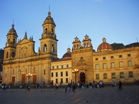
Bogotá Bogotá, D.C. (D.C. for "Distrito Capital", which means "Capital District"), formerly called Santa Fe de Bogotá is the capital city of Colombia, as well as the most populous city in the country, with 6,776,009 inhabitants (2005). Bogotá and its metropolitan area, which includes municipalities such as Chia, Cota, Soacha, Cajicá and La Calera, had an estimated population of 8,244,980. In terms of land area, Bogotá is also the largest in Colombia, and its altitude (2,640 metres) makes it the third-highest major city in the world, after La Paz and Quito. With its many universities and libraries, Bogotá has become known as "The Athens of South America". Bogotá - Capital city
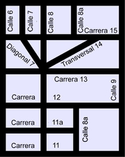
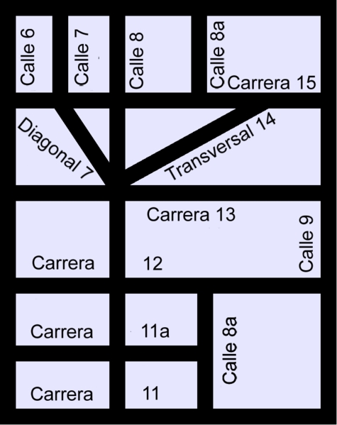
Motto: Bogotá, 2650 metros más cerca de las estrellas Bogotá, 2600 meters closer to the stars Coordinates: 4°35'53"N 74°4'33"W Country: Colombia Department: Cundinamarca Founded: August 6, 1538 Founder: Gonzalo Jiménez de Quesada Area: - City 1,587 km² (612.7 sq mi) - Land 1,731.9 km² (668.7 sq mi) Elevation: 2,640 m (8,661 ft) Population: (2005 census) - City 6,776,009 Ranked 1st - Density 22,593/km² (11,071/sq mi) - Metro 7,881,156 HDI: (2006) 0.830 high Websites: City Official Site Mayor Official Site Bogotá Tourism History Bogotá was originally called "Bacatá;" (which means "planted fields") by the Muiscas. It was the centre of their civilisation before the Spanish explorers colonised the area, and it sustained a large population. The European settlement was founded on August 6, 1538 by Gonzalo Jiménez de Quesada and was named "Santa Fé de Bacatá" after his birthplace Santa Fé and the local name. "Bacatá" had become the modern "Bogotá" by the time it was made the capital of the New Kingdom of Granada, which was then part of the Viceroyalty of Peru, and later of the Viceroyalty of New Granada. The city soon became one of the centres of Spanish colonial power and civilization in South America. In 181011 its citizens revolted against Spanish rule and set up a government of their own, but had to contend with internal divisions and the temporary return to power of Spanish military loyalists who regained control of the city in 1816. In 1819 Simón Bolivar liberated it after his victory at Boyacá. Bogotá was then made the capital of Gran Colombia, a federation combining the territories of modern Panama, Colombia, Venezuela, and Ecuador. When Gran Colombia was broken Bogotá remained the capital of New Granada, which later became the Republic of Colombia. In 1956 the municipality was joined to other neighbouring municipalities forming a "Special District" (Spanish: Distrito Especial). The Constitution of 1991 confirmed Bogotá as the Capital of Colombia, gave it the name "Santa Fé de Bogotá", and changed the category from Special District to "Capital District" (Distrito Capital). In August 2000 the name was officially changed back to simply "Bogotá". Location Bogotá is located near the geographic centre of Colombia, on the east of the Savannah of Bogotá (Sabana de Bogotá), 2640 meters (8661 ft) above sea level. Although it is located in what is popularly called the "sabana", literally meaning "savannah", the geographical site is actually a high plateau in the Andes mountains. The extended region is also known as "Altiplano Cundiboyacense" which literally means "high plateau of Cundinamarca and Boyacá". The Bogotá River crosses the 'sabana' forming Tequendama Falls (Salto de Tequendama) to the south. Tributary rivers form valleys with flourishing villages, whose economy is based on agriculture, livestock raising and artisanal production. The 'sabana' is bordered to the east by the Eastern Cordillera of the Andes mountain range. Surrounding hills, which limit city growth, run from south to north, parallel to the Guadalupe and Monserrate mountains. The western city limit is the Bogotá River. The Sumapaz paramo (moorland) borders the south and to the north Bogotá extends over the mentioned plateau up to the towns of Chia and Sopó. Climate The average temperature on the 'sabana' is 14.0°C, varying from 3°C to 25°C. Dry and rainy seasons alternate throughout the year. The driest months are December, January, February and March; the rainiest are April, May, September, October and November. June and July are usually rainy periods and August is sunny with high winds. Hailstorms are common during the rainy season, and can be very strong, especially in October. Climatic conditions are irregular and quite variable due to the El Niño and La Niña climatic phenomena, which occur in and around the Pacific basin and are responsible for very pronounced climatic changes. Even with this fact, overall, all year days are mild or cool and nights can get very cold due to the city having windy nights year round. 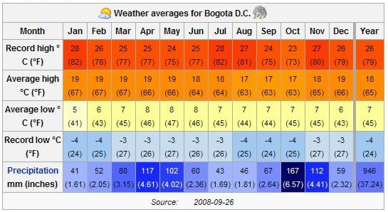 Urban layout and nomenclature Bogotá has over one thousand localities, forming an extensive network of neighbourhoods. Areas of higher economic status tend to be located to the north and north-east, close to the foothills of the Eastern Cordillera. Poorer neighbourhoods. are located to the south and south-east, many of them squatter areas. The middle classes usually inhabit the central, western and north-western sections of the city. The urban layout in the centre of the city is based on the focal point of a square or plaza, typical of Spanish-founded settlements, but the layout gradually becomes more modern in outlying neighbourhoods. The current types of roads are classified as calles (streets), which run perpendicular to the Cordillera, with street numbers increasing towards the north, and also towards the south (with the suffix "Sur") from Calle 1. Carreras run parallel to the hills, with numbering increasing as one travels east or west of Carrera 1 (with the suffix "Este" for roads east of Carrera 1). Other types of roads more common in newer parts of the city may be termed "Eje" (Axis), "Diagonal" or "Transversal". Street arrangement of Bogotá based on the Cartesian coordinate system. The numbering system for street addresses recently changed, and numbers are assigned according to street rank from main avenues to smaller avenues and local streets. Some of Bogota's main roads, which also go by a proper name in addition to a number, are: * Norte-Quito-Sur or N.Q.S.(North Quito South Avenue, from 9th road at north following railway to 30th road Avenue, or Quito City Avenue, and Southern Highway) * Autopista Norte-Avenida Caracas (Northern Highway, or 45th road, joined to Caracas Avenue, or 14th road) * Avenida Circunvalar (from downtown following hillside on eastern hills going to La Calera) * Avenida Suba (60th transversal from 100th street to the Suba Hills; 145th street from Suba Hills westward) * Avenida El Dorado (El Dorado Avenue, or 26th street) * Avenida de las Américas (Americas Avenue, from 34th street at east to 6th street at west) * Avenida Primera de Mayo (May First Avenue, or 22nd south street) * Avenida Ciudad de Cali (Cali City Avenue, or 86th road) * Avenida Boyacá (Boyacá Avenue, or 72nd road) * Autopista Sur (Southern Highway) Divisions 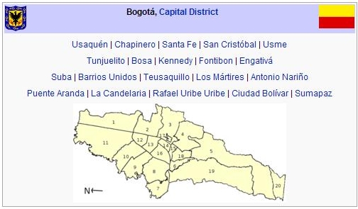
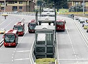
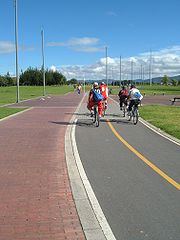
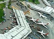
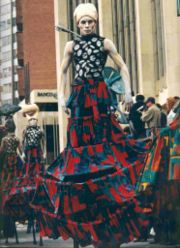
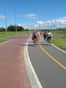
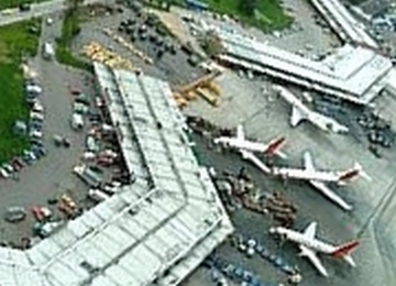
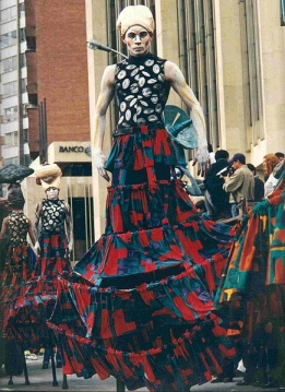
Demographics The largest and most populous city in Colombia, Bogotá has 7,881,156 inhabitants in its metropolitan area (2005 census), with a population density of approx. 3912 inhabitants per square kilometer. 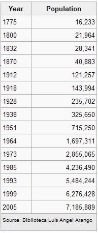 Only 15,810 people are located in rural areas of Capital District. 47.5% of the population are male and 52.5% women. The city has the lowest rate of illiteracy in the country which reaches only 4.6% of the population older than 5 years old. Public services have a high coverage, since a 99.5% of households have electricity service, while 98.7% have service of an aqueduct and 87.9% have telephone communication. However, as the mission to design a strategy for poverty reduction and inequality, in 2005 the city had a 32.6% of poor (people living on less than U.S. $ 2.0 a day). In Bogotá, as in the rest of the country, the accelerating of the urbanisation process is not only due to industrialisation, since there are complex political and social reasons such as poverty and violence which have led to migration from rural to urban areas throughout the twentieth century. This has led to an exponential growth of population in urban areas and belts of misery in their surroundings. A dramatic example of this is the number of displaced people who have arrived in Bogotá. According to the Consultancy for Human Rights, Codhes, in the period 1999-2005 more than 260,000 people arrived in Bogotá as a result of displacement, about 3.8% of the total population of Bogotá. The majority of the displaced population lives in the Ciudad Bolivar, Kennedy, Usme, and Bosa sections. The composition of the city's population is of mestizo origin (those of mixed Amerindian and white European descent), in addition to white European descent, mostly of Spaniard, Italian, French, German, and other European ancestry. It has a very large Middle Eastern population, made up mostly of Lebanese and Syrian immigrants. The population of Colombians, of african descent, in Bogotá is smaller than cities along the coast such as Cartagena, where Colombians, of african descent, have historically resided. Social Order The past leaders of the city have made public campaigns aimed at reducing its high crime rates. According to recent official report of District Administration, in the last ten years has decreased from 89.4 violent deaths per 100,000 inhabitants in 1996 to 37.9 in 2005, which represents a reduction of 57.6%, keeping in mind that in the same period the population increased more than 25%. Of these violent deaths, 62.8% occurred by murder, while 20.5% were caused by traffic accidents; this report also reveals that 85.1% of the victims were men and 14.9% women. Crime Bogotá has gone to great lengths to change its crime rate and its image with increasing success after being considered in the mid-90s one of the most violent cities in the world. In 1993 alone it had 4,352 intentional homicides and a rate of 80 per 100,000 people. The success was the result of a participatory and integrated security policy, "Communidad Segura", that was first adopted in 1995 and continues to be enforced. In 2007, Bogotá has one of had a murder rate of 20 persons per 100,000 inhabitants with 1,401 fatalities. It should be stated that these figures, both in terms of volume and rate, remain far higher than equivalent US urban areas such as Philadelphia, Washington and Atlanta. Today, Bogotá has a lower murder rate than Caracas, and Rio de Janeiro. Government Bogotá is the capital of the Republic of Colombia, and houses the national legislature, the Supreme Court of Justice, and the centre of the executive administration as well as the residence of the President of the Republic. The Principal Mayor and District Council both elected by popular vote are responsible for city administration. In 2007 Samuel Moreno Rojas was elected Mayor for the period 2008-2011. The city divided into 20 localities: Usaquén, Chapinero, Santa Fe, San Cristóbal, Usme, Tunjuelito, Bosa, Kennedy, Fontibón, Engativá, Suba, Barrios Unidos, Teusaquillo, Los Mártires, Antonio Nariño, Puente Aranda, La Candelaria, Rafael Uribe, Uribe, Ciudad Bolivar, Sumapaz. Each of the 20 localities are governed by an administrative board elected by popular vote, made up of no less than seven members. The Principal Mayor designates local mayors from candidates nominated by the respective administrative board. Economy Bogotá is Colombia's largest economic centre (followed by Medellin, Cali and Barranquilla), and one of the most important in Latin America. Its GDP of US$86 billion, almost a quarter of Colombia's total, is the fifth highest among cities in South America. Most companies in Colombia have their headquarters in Bogotá (for example, Bavaria, Avianca), it is the site of Colombia's main stock exchange. Bogotá is also a major cent er for the import and export of goods for Colombia and the Andean Community in Latin America. Bogotá is the centre of Colombian business, and the city's industrial base include staples of the Colombian economy such as GM Colmotores, Compañia Colombiana Automotriz, and Ecopetrol. Other important industries include financial services, especially banking. Bogotá is the headquarters of major commercial banks, and of the Banco de la República, Colombia's central bank. Bogotá is a centre of printing and publishing, as well as of the national telecommunications network and has the biggest industrial facilities in the country. Bogotá also houses the central governmental institutions and military headquarters, which represent another major component of the city's economy. The city is also a major convention destination with major convention centres including Centro Ferial de Convenciones Corferias, Centro de Convenciones y Eventos Cafam, Centro de Convenciones Gonzalo Jiménez de Quesada, among others. Infrastructure Energy and sewer bills are stratified based on the location of owner's residence, with the intended purpose that wealthier sections of society subsidise the energy bills of the poorer sections of society. Telephone service is provided by both "Empresa de 07) three main operators of wireless phones: Movistar (owned by Spanish firm Telefónica), Comcel (owned by Telmex) and Tigo (co-owned by ETB, EPM and Millicom). Transportation Bogotá's growth has placed a strain on its roads and highways, but within the past decade significant efforts to upgrade the infrastructure have been undertaken. Private car ownership, despite being under 25%, forms a major part of the congestion, in addition to taxis, buses and commercial vehicles. Buses remain the main means of mass transit. There are two bus systems: the traditional system and Trasmilenio. The traditional system runs a variety of bus types, operated by several companies on normal streets and avenues: Bus (large buses), Buseta (medium size buses) and Colectivo (vans or minivans). The bigger buses were divided into two categories: "Ejecutivo", which is supposed to be a deluxe service and is not supposed to carry standing passengers, and "corriente" or normal service. Bus fares range, as of March 2008, from $1100 to $1250 (US$ 0.60-0.70 approx.). Since May 2008, all buses run as "corriente" services. Bogotá is a hub for domestic and international bus routes. The Bogotá terminal serves routes to most cities and towns in Colombia and is the largest in the country. There is international service to Ecuador and Venezuela. The TransMilenio rapid transit system, created during Enrique Peñalosa's mayoral term, is a form of bus rapid transit that has been quickly and affordably deployed as an appropriate stopgap measure to compensate for the lack of a metro system. TransMilenio combining articulated buses that operate on dedicated bus roads (busways) and smaller buses (feeders) that operate in residential areas, bringing passengers to the main grid. TransMilenio's main routes are: Caracas Avenue, Northern Highway (Autopista Norte), 80th Street, Americas Avenue, Jiménez Avenue, and 30th Avenue (also referred to as Norte Quito Sur or N.Q.S. for short). Routes for Suba Avenue and Southern Highway (Autopista Sur), the southern leg of the 30th Avenue, were opened in April 2006. The third phase of the system will cover 7th Avenue, 10th Avenue, and 26th Street (or Avenida El Dorado). The system is planned to cover the entire city by 2030. Although the Transmilenio carries commuters to numerous corners of the city, it more expensive than any public transport except taxis, and fares increase with petroleum fuel prices. As of December 2007 the price of a ticket was $1400; however, a single ticket allows unlimited transfers until the passenger leaves the system, and passengers travel on feeder routes for free. Transmilenio does not yet cover some main routes, and buses are overcrowded. Despite the city's chronic congestion, many of the ideas enacted during the Peñalosa years are regarded worldwide to be cost-effective, efficient and unique solutions. In addition to TransMilenio, the Peñalosa administration and voter-approved referenda helped to establish travel restrictions on private cars during peak hours called Pico y placa, "Car Free Days" on Sundays, a massive system of bicycle paths and segregated lanes called 'ciclorrutas', and the removal of thousands of parking spots in an attempt to make roads more pedestrian-friendly. Ciclorrutas is one of the most extensive dedicated bike path networks of any city in the world, with a total extension of 303 km. It extends from the north of the city, 170th Street, to the south, 27th Street, and from Monserrate on the east to the Bogotá River on the west. The ciclorruta was started by the 19951998 Antanas Mockus administration, and considerably extended during the administration of Mayor Peñalosa. Since the construction of the ciclorrutas bicycle use in the city has increased. Airports Bogotá's principal airport is El Dorado International Airport, west of the city's downtown, at the end of Av. El Dorado. Due to its central location in Colombia and in Latin America, it is a natural hub for domestic and international airlines. El Dorado is heavily congested, as it handles more passengers than its optimal capacity. Work on a major expansion of El Dorado airport started in September 2007. When completed, this will expand capacity from the current 8 million passengers a year to 16 million. A secondary airport, Catam, serves as a base for Military and Police Aviation, also Guaymaral Airport, for private aviation activities. Colleges and universities Known as the Athens of South America, Bogotá has more schools, colleges, and universities than any other city in Colombia and a scholarly tradition that dates back to July 13, 1580, when the first university, Saint Thomas Aquinas University, was founded by the Dominicans. On July 9, 1623 the Pontifical Xavierian University was founded by the Jesuits and on December 31, 1651 the Our Lady of the Rosary University by Cristóbal de Torres. The largest university in Colombia, the Universidad Nacional de Colombia, was founded on September 22, 1867. A study by Universia found it to be the Colombian university producing the largest number of scientific papers published in peer-refereed publications in 2005, and the 45th most prolific in Latin America. Other notable universities include the Universidad Externado de Colombia, founded in 1886, and the University of the Andes, founded in 1948, which is the only Colombian university ranked amongst the top 500 of the world. Culture Parks and recreation Primary Cathedral, Bogotá There are many parks, many with facilities for concerts, plays, movies, storytellers and other activities. * "Simón Bolivar Metropolitan Park" is a large park regularly used to stage free concerts (such as the annual Rock al Parque, a festival in which new and popular Latin rock bands play free of charge). Kites are flown in the park. * The public Parque Nacional (National Park)has many trees and green spaces, ponds, games for children, many foot and bicycle paths, and venues for entertainment such as public screenings of movies and concerts and events organized by the Council of Bogotá. It is located between two main streets, the Circunvalar Avenue and the 7th Avenue. * The Bogotá Botanical Garden (Jardin Botánico de Bogotá). * "Parque de la 93" is located between 93rd and 93Ath street, and 12th and 13th avenue, and has day-time leisure activities and nightlife. Several of the top restaurants and bars in the city are in this park. * There are restaurants and bars in the vicinity of a T-shaped pedestrian strip dubbed "La T" (The T) at the corner of 82nd street and Cra.12. More recently, restaurant activity has begun in the " Zona G" (Gourmet Zone) in and around 67th and 70th Streets and other locations including Usaquen in the north-east and La Macarena (downtown). * Mundo Aventura is an amusement park, with an entry charge and charges for the different attractions. It has rides for adults and children, a petting zoo, and the "cerdodromo", where pigs race. * "Salitre Mágico" is another amusement park with rides and attractions. The park is near the well-known Simón Bolivar park, where concerts are held throughout the year. * Parque del Chicó has trees, gardens, artificial creeks and ponds, and a colonial style house converted into a museum. * To the north Parque Jaime Duque has rides, a giant map of Colombia, popular exhibits, a zoo, and a big hand holding the world symbolizing God. There is a reproduction of the Taj Mahal in the park with a collection of reproductions of famous paintings. The park is also used for large concerts, mainly electronic music ones. * Maloka is an interactive museum of sciences. * Tourist train, on weekends a sightseeing train, popular with Bogotá residents, runs to outlying towns Zipaquirá, Cajicá and Nemocón along the lines of the former Bogotá Savannah Railway. The route to Zipaquirá (famous for its salt cathedral) is 53 km long. Another line goes towards the north for 47 km and ends at Briceño. Bogotá is known for its vibrant night life. It has a wide variety of restaurants, bars, clubs and cultural activities to please anyone's preference. There are numerous zones including the T, Parque de la 93, Candelaria, Usaquen, Avenida Primero de Mayo and Zona G among others. Places range from fine cuisine from all over the world to night clubs that offer different types of music. There is a curfew for most night places at 3:00am although some clubs still operate after hours. Symbols The flag originates from the insurgency movement against the colonial authorities which began on July 20, 1810, during which the rebels wore armbands with yellow and red bands, as these colours were those of the Spanish flag used as the flag for the New Kingdom of Granada. In October 9, 1952, exactly 142 years after these events, decree 555 of 1952 officially adopted the patriotic armband as the flag of Bogotá. The flag of Cundinamarca follows the same pattern, plus a light blue tile which represents the Virgin Mary's cape. The flag itself is a yellow band above a red one. The yellow denotes the gold from the earth, as well as the virtues of justice, clemency, benevolence, the so-called "mundane qualities" (defined as nobility, excellence, richness, generosity, splendour, health, steadfastness, joy and prosperity), long life, eternity, power and constancy. The red denotes the virtue of charity, as well as the qualities of bravery, nobility, values, audacity, victory, honour and furor, Colombians call it the blood of their people. The coat of arms of the city was granted by emperor Charles V (Charles I of Spain) to the New Kingdom of Granada, by royal decree given in Valladolid, Spain on December 3, 1548. It contains a black eagle in the centre, which symbolises steadfastness. The eagle is also a symbol of the Habsburgs, which was the ruling family of the Spanish empire at the time. The eagle is crowned with gold and holds a red pomegranate inside a golden background. The border contains olive branches with nine golden pomegranates in a blue background. The two red pomegranates symbolize audacity, and the nine golden ones represent the nine states which constituted the New Kingdom of Granada at the time. In 1932 the coat of arms was officially recognised and adopted as the symbol of Bogotá. The lyrics to the anthem of Bogotá were written by Pedro Medina Avendaño, the melody was composed by Roberto Pineda Duque. The song was officially declared the anthem by decree 1000 of July 31, 1974, by then Mayor of Bogotá, Anibal Fernandez de Soto. 
About Wikipedia Disclaimers
Other pages in my Colombia series.
Site Index Back to Top Photos Index Thanks for coming, I hope you
have enjoyed it, will recommend
it to your friends, and will come
back later to see my site developing
and expanding.
|

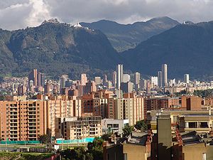


 Panoramic view of downtown Bogota
