North Island
New Zealand facts & history in brief
 New Zealand Map
Wanganui
is a service city and commercial
centre for a rich, sheep farming region,
near the mouth of the Wanganui River,
with nearby Castlecliff's port facilities.
Often called the 'River City'.
Edward Jerningham Wakefield purchased
some land in 1840 for the settlement
and it was called Petre in the
beginning after Baron Petre,
one of the New Zealand Company directors.
Europeans are known to have visited
the area long before that for
trading and collecting signatures
for the Treaty of Waitangi.
Wanganui was a very early and
prosperous settlement in the country.
Maori settlement goes back a long
time with a large number of easily
fortified pas on the cliffs along
its length, and many territorial
wars were fought
over it by many tribes.
It was declared a city in 1924.
Present population is about 50.000.
When I lived there for a few months
in the late 1950's, the city was
very colourful, beautiful and very
friendly.
Tops in my book.

You can click on these photos for an enlargement.
 |
 |
 |
|
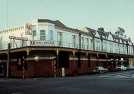
Wanganui |
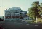
Wanganui |
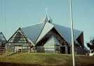
Wanganui |
Site
Index
Back to Top
Photos Index
Thanks for coming, I hope you
have enjoyed it, will recommend
it to your friends, and will come
back later to see my site developing
and expanding.
I'm trying to make my pages
enjoyable and trouble free for everyone,
please let me know of any mistakes
or trouble with links, so I can
fix any problem as soon as possible.
These pages are best viewed with
monitor resolution set at
800x600 and kept simple on purpose
so everyone can enjoy them
across all media and platforms.
Thank you.
Webmaster

|