North Island
New Zealand facts & history in brief
 New Zealand Map
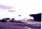
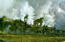
Wairakei
is about ten km north of
Taupo, sits an active volcanic
fault that runs from White Island,
in the Bay of Plenty through
Rotorua, Taupo to Mount Ruapehu.
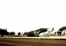
Wairakei's 'Geyser Valley' has
been a tourist attraction
since the 1880's.
Wairakei's geothermal station
was the second in the world
when it was opened in 1958.
The scheme is tapping the
underground water system that
is heated by very hot
volcanic rocks, deep
below the surface.
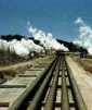
Drilling goes down to 600 metres,
to fissures in the lower rock
strata to obtain steam at
the highest pressures.
More than 100 bores have been
drilled, but not all produced
economic quantities of steam.
Now there are many similar plants
world-wide.

You can click on these photos for an enlargement.
 |
 |
 |
 |
|
Wairakei |
Wairakei |
Wairakei |
Wairakei |
Site
Index
Back to Top
Photos Index
Thanks for coming, I hope you
have enjoyed it, will recommend
it to your friends, and will come
back later to see my site developing
and expanding.
I'm trying to make my pages
enjoyable and trouble free for everyone,
please let me know of any mistakes
or trouble with links, so I can
fix any problem as soon as possible.
These pages are best viewed with
monitor resolution set at
800x600 and kept simple on purpose
so everyone can enjoy them
across all media and platforms.
Thank you.
Webmaster

|