New Zealand
New Zealand facts & history in brief
 New Zealand Map
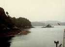
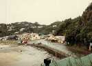
Stewart Island
is 1746 km² island, 30 km from
the south of the South Island
separated by the Foveaux Strait.
The main economic activities are
fishing, farming and forestry.
In 1770 Captain Cook called it
the South Cape, mistakenly assuming
it to be part of the South Island.
The 19th century sealers frequenting
the island knew better.
Named after Captain William Stewart,
who charted the island in 1809.
The government bought the island
in 1864 for £6.000, from the Maori
owners.

You can click on these photos for an enlargement.
 |
 |
 |
 |
|
Stewart Island |
Stewart Island |
Stewart Island |
Stewart Island |
Site
Index
Back to Top
Photos Index
Thanks for coming, I hope you
have enjoyed it, will recommend
it to your friends, and will come
back later to see my site developing
and expanding.
I'm trying to make my pages
enjoyable and trouble free for everyone,
please let me know of any mistakes
or trouble with links, so I can
fix any problem as soon as possible.
These pages are best viewed with
monitor resolution set at
800x600 and kept simple on purpose
so everyone can enjoy them
across all media and platforms.
Thank you.
Webmaster

|