|
|
|
|
|
|
|
|
|
|
|
|
MangonuiNorth Island - New Zealand
New Zealand facts & history in brief
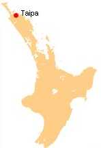
Taipa-Mangonui  Taipa-Mangonui is one name given to a string of small resort settlements in the far north of New Zealand's North Auckland Peninsula, close to the base of the Aupouri Peninsula. The resorts of Taipa, Cable Bay, Cooper's Beach, and Mangonui, all of which lie along the coast of Doubtless Bay, are so close together that they have run together to form one larger settlement with a combined population of 1569 (2006 census). The "miniature conurbation" lies 150 kilometres by road northwest of Whangarei (though only 100 kilometres as the crow flies), and 20 kilometres northeast of Kaitaia. It is thus the northernmost centre in New Zealand with a population of above 1000, even though it is nearly 100 kilometres southeast of the northernmost tip of the North Island. Education Taipa Area School is a composite (years 1-15) school with a roll of 464. The school claims to be the only one in New Zealand to have a team of students who are qualified surf lifeguards patrolling beach activities during terms 1 and 4. Mangonui School is a contributing primary (years 1-6) school with a roll of 151. The school opened in 1857, and one of the original buildings is still in use as the school library. Both schools are coeducational and have a decile rating of 3.
All text is available under the terms of the GNU Free Documentation License (see Copyrights for details). About Wikipedia Disclaimers
2009
Site Index Back to Top Photos Index Thanks for coming, I hope you
have enjoyed it, will recommend
it to your friends, and will come
back later to see my site developing
and expanding.
|