North Island
New Zealand facts & history in brief
 New Zealand Map
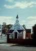
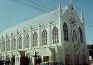
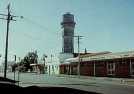
Hawera
is a major town of south
Taranaki, about 20 km south of Eltham
and 27 km north-west of Patea, with
a population of around 13,000.
Hawera was a borough from 1882,
until it became a part of the county.
Hawera is a servicing and distributing
centre for the surrounding prosperous
dairying district.
The township is about 20 km from
the Kapuni natural gas field.
In the 1860s some of the heaviest
fighting of the 'Land Wars' taken place
in and around Hawera.
In 1866 about 20 000 ha of Maori
land was confiscated
for military settlement.
The Maoris under the leadership
of Te Whiti of Parihaka Pa, fought a
long and passive resistance.
Hawera decided to secede from the
colony under the leadership of local
farmer James Livingstone and
become an independent republic with
a volunteer army.
The Government rushed in troops
to put down the rebellion of the
settlers and Te Whiti.

You can click on these photos for an enlargement.
Site
Index
Back to Top
Photos Index
Thanks for coming, I hope you
have enjoyed it, will recommend
it to your friends, and will come
back later to see my site developing
and expanding.
I'm trying to make my pages
enjoyable and trouble free for everyone,
please let me know of any mistakes
or trouble with links, so I can
fix any problem as soon as possible.
These pages are best viewed with
monitor resolution set at
800x600 and kept simple on purpose
so everyone can enjoy them
across all media and platforms.
Thank you.
Webmaster

|