South Island
New Zealand facts & history in brief
 New Zealand Map
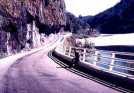
Buller Gorge
is the main and very scenic thoroughfare between
Nelson or Blenheim and Westport cities.
The pass goes beside the Buller river in a gorge
of the Southern Alps.
The road passes Murchinson and the Inangahua Junction,
both memorable in New Zealand history for devastating
earthquakes.
Murchison is a small settlement near the junction
of the Matakitaki and Buller Rivers.
Used to be called Hampden, but
was renamed Murchison for the
nearby Mount Murchison (1470 m).
Mount Murchison was named after Scottish geologist,
Sir Roderick Murchison, who founded
the Royal Geographical Society.
The centre of an earthquake on 17 June 1929
was near Murchison and was felt practically
all over New Zealand.
The earthquake devastated Murchison and
killed about seventeen people in the
district.
Inangahua Junction is another small
settlement in the Buller Gorge region,
near where the Inangahua River
joins the Buller River about 45 km
from Westport.
The township is famous for its whitebait,
and bears the Maori name inanga for whitebait.
The earthquake, centred near Inangahua,
was was felt nation wide in May 1968
caused a lot of damage throughout the county,
shifted large areas of the ground surface
and killed three people.

You can click on these photo for an enlargement.
 |
|
Buller Gorge |
Site
Index
Back to Top
Photos Index
Thanks for coming, I hope you
have enjoyed it, will recommend
it to your friends, and will come
back later to see my site developing
and expanding.
I'm trying to make my pages
enjoyable and trouble free for everyone,
please let me know of any mistakes
or trouble with links, so I can
fix any problem as soon as possible.
These pages are best viewed with
monitor resolution set at
800x600 and kept simple on purpose
so everyone can enjoy them
across all media and platforms.
Thank you.
Webmaster

|