
Cyprus
Excerpted from Wikipedia, the free encyclopedia.
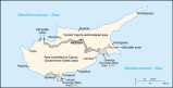
Map of Cyprus
Cyprus
facts and history in brief

Other pages in my Cyprus series
Larnaka  Nicosia (Lefcosia)
Nicosia Green Line (Lefcosia)
Nicosia (Lefcosia)
Nicosia Green Line (Lefcosia)
The Republic of Cyprus (Greek: Kypros; Turkish: Kibris)
is an island nation in the eastern Mediterranean Sea,
113 kilometres (70 miles) south of Turkey and
around 120 km west of the Syrian coast.
Details:
Name: in Greek; Kibris Cumhuriyeti,
in English; Republic of Cyprus
Motto: None
Anthem: Ymnos pros tin Eleutherian #1
Capital: Nicosia (pop. 200,686)
Largest city: Nicosia (Officially: Lefcosia)
Official languages: Greek and Turkish
Independence: Declared; 16 August 1960, #2
Recognised; from the UK 16 August 1960.
Area: 9,250 4 km² #3
Population: 780,133 . 2005 est. #4
Currency: Cyprus Pound (CYP)
Time zone: EEST (UTC+3)
. Summer (DST) EET (UTC+2)
Internet TLD: .cy
Calling code: +357 #5
1. "Ymnos pros tin Eleutherian" is also used as
the national anthem of Greece.
The TRNC uses the Turkish national anthem
2. Not recognised by Turkey, which instead recognises TRNC
3. Of which 5,895 km² is in the south and 3,355 km² in the north
4. Number does not include 323,657 inhabitants in the north
5. +90-392 (a Turkish access number) is used in the north
Name and position
The word for the metal "copper" in the English
language (and many other languages) stems from
the Latin phrase aes Cyprium , "metal of Cyprus",
later shortened to cuprum, "copper".
Large deposits of copper are found on the island.
Cyprus is geographically in Western Asia
(or the Near East), though politically and
culturally it is considered as being in Europe.
Historically, Cyprus has always been a bridgehead
between Europe and Asia, with interchanging
periods of Levantine, Anatolian,
and Greek influences.
Political division
Cyprus gained independence from the United
Kingdom in 1960, with the UK, Greece and
Turkey retaining limited rights to
intervene in internal affairs.
The Republic of Cyprus is the
internationally recognised government
of the island, and it controls the
southern two-thirds of the island.
Almost all foreign governments and the
United Nations recognise the sovereignty
of the Republic of Cyprus over
the whole island of Cyprus.
Turkish Cypriots, together with Turkey,
do not accept the Republic's rule over
the whole island and call it the "Greek
Authority of Southern Cyprus".
They control the northern third of the
island, following a military
invasion by Turkey in 1974.
This happened following a coup sponsored
by the military regime of Greece.
The Turkish Cypriot area proclaimed its
independence in 1975, and the self-styled
Turkish Republic of Northern Cyprus was
established in 1983.
This state was recognised only by Turkey.
Furthermore, Organization of the Islamic
Conference granted it observer member
status under the name of
"Turkish Cypriot State".
The other power with territory on
Cyprus is the United Kingdom.
Under the independence agreement, the UK
retained title to two areas on the southern
coast of the island, around Akrotiri and
Dhekelia, known collectively as
the UK sovereign base areas.
They are used as military bases.
Reunification
Negotiations have been on going for years
to reunite the island, but have not
as yet seen substantial success.
A United Nations plan, announced on
31 March 2004 following talks in Switzerland,
was put to both sides in separate
referenda on 24 April 2004.
On the referendum, the proposed reunification
was favoured by the Turkish Cypriots by a
majority of 2 to 1, but was rejected by
the Greek Cypriots by a 3 to 1 margin.
As a result, while officially the whole of
Cyprus entered the European Union on
1 May 2004, the de facto EU border runs along
the Green Line, dividing the country between
the Greek and Turkish Cypriot parts.
EU law is currently not applied in
the Turkish occupied north.
The Union has promised to send aid in the
form of money and work towards lifting the
trade sanctions imposed by the European Court,
but they have ruled out diplomatic
recognition of northern Cyprus.
As to date, the self declared Turkish Republic
of Northern Cyprus, recognized only by Turkey,
has yet to see any promised aid
or easing of trade sanctions.
History
There are but scanty traces of the Stone Age,
but the Bronze Age is characterized by a
well-developed and clearly marked civilization.
The people early learned to work the rich
copper mines of the island.
The Mycenæan civilization of the West seems to
have reached the island around 1600 B.C.
The Greek and Phonician settlements
belong to the Iron Age.
The island was invaded by Thothmes III of Egypt
about 1500 B.C., and was forced to pay tribute.
In the eighth century before Christ it was
tributary to the Assyrians.
Cyprus has been badgered by its powerful nearby
nations for more than 3,000 years.
In ancient times Cyprus supplied the
Greeks with timber for their fleets.
In the sixth century B.C., Amasis of Egypt
conquered Cyprus, which soon fell under the
rule of the Persians when
Cambyses conquered Egypt.
Alexander the Great (356-323 B.C.) wrested
the island away from the Persians.
Later, Egypt controlled it, then
Rome annexed it in 58-57 BC.
During the reign of Trajan (116 AD), an
estimated 240,000 people were slain when
it was the scene of a rising by the Jews,
who were defeated by the Romans everywhere
in the Roman Empire about 137 and
scattered to many places.
Byzantine emperors took control after the
partitioning of the Roman Empire, then
Arabs took control in 646.
Greeks, Arabs, and Byzantine emperors badgered
Cyprus until 1184 when Isaac Comnenus of Cyprus
made Cyprus an independent sovereignty.
The Republic of Venice took control in 1489,
after which the Turks invaded
and took control in 1570.
Cyprus was placed under British control on July 12,
1878 due to the proceedings at the Congress of Berlin.
Compulsory reafforestation has been
introduced into Cyprus.
The Famagusta harbor was completed
in June, 1906.
Cyprus was ceded to United Kingdom in 1913.
Geography
The central plain (Mesaoria) with the
Kyrenia/Girne and Pentadactylos/Besparmak
mountains to the north and the Troodos mountain
range to the south and west.
There are also scattered but significant
plains along the southern coast.
The climate is temperate, Mediterranean
with hot, dry summers and cool,
variably rainy winters.
External links

This page was retrieved and condensed from
(http://en.wikipedia.org/wiki/Cyprus)
August 2005
All text is available under the terms of the
GNU Free Documentation License (see
Copyrights for details).
Other pages in my Cyprus series
Larnaka
Nicosia (Lefcosia)
Nicosia Green Line (Lefcosia)
Site
Index
Back to Top
Photos Index
Thanks for coming, I hope you
have enjoyed it, will recommend
it to your friends, and will come
back later to see my site developing
and expanding.
I'm trying to make my pages
enjoyable and trouble free for everyone,
please let me know of any mistakes
or trouble with links, so I can
fix any problem as soon as possible.
These pages are best viewed with monitor
resolution set at 640x480 and kept simple
on purpose so everyone can enjoy them
across all media and platforms.
Thank you.
You can e-mail me at
Webmaster

|
