|
|
|
|
|
|
|
|
|
|
|
|
South Georgia and the South Sandwich IslandsSouth Georgia
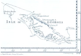
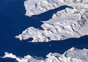
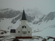
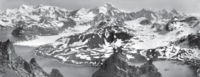
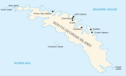
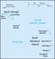
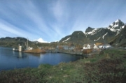
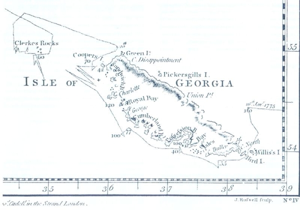
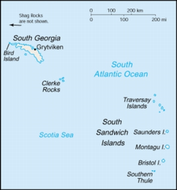
"Let the Lion protect his own land" or "May the Lion protect his own land" Anthem: "God Save the Queen" Capital: King Edward Point (Grytviken) Official language: English Government: British Overseas Territory Area: - Total 3,903 km², 1,507 sq mi Population: - 2006 estimate ~20 (n/a) - Density 0.005/km² (n/a) 0.013/sq mi Currency: Pound sterling (GBP) Time zone: (UTC-2) Drives on the left Internet TLD: .gs History The Island of South Georgia is said to have been first sighted in 1675 by Anthony de la Roche, a London merchant, and was named Roche Island on some early maps, Pepys Island on others. It was sighted by a commercial Spanish ship named Leon operating out of Saint-Malo on 28 June or 29 June 1756. In 1775 Captain James Cook circumnavigated the island, made the first landing, claimed the territory for the Kingdom of Great Britain, and named it "the Isle of Georgia" in honour of King George III. British arrangements for the government of South Georgia were first established under the 1843 British Letters Patent. In 1882 a German expedition sent out to observe the transit of Venus was stationed at Royal Bay on the south-east side of the island. Throughout the 19th century South Georgia was a sealers' base and, in the following century, a whalers' base until whaling ended in the 1960s. The first land-based whaling station, and first permanent habitation, was established at Grytviken in 1904 by Norwegian Carl Anton Larsen. It operated through his Argentine Fishing Company, which settled in Grytviken. The station remained in operation until 1965. Whaling stations operated under leases granted by the (British) Governor of the Falkland Islands. The seven stations, all on the north coast with its sheltered harbours were, starting from the west: * Prince Olav Harbour (from 1911-1916 factory ship and small station, land-based station 1917-1931) * Leith Harbour (1909-1965) * Stromness (from 1907 factory ship, land-based station 1913-1931, repair yard to 1960/1961) * Husvik (from 1907 factory ship, land-based station 1910-1960, not in operation 1930-1945) * Grytviken (1904-1964) * Godthul (1908-1929, only a rudimentary land base, main operations on factory ship) * Ocean Harbour (1909-1920) With the end of the whaling industry the stations were abandoned. Apart from a few preserved buildings such as the museum and church at Grytviken, only their decaying remains survive. From 1905 the Argentine Meteorological Office cooperated in maintaining the meteorological observatory at Grytviken under the British lease requirements of the whaling station until these changed in 1949. In 1908 the United Kingdom issued a further Letters Patent to establish constitutional arrangements for its possessions in the South Atlantic. As well as South Georgia, the Letters Patent covered the South Orkneys, the South Shetlands, the South Sandwich Islands, and Graham Land. (The claim was extended in 1917 to also include a sector of Antarctica reaching to the South Pole.) From 1909 an administrative centre and residence was established at King Edward Point on South Georgia, near the whaling station of Grytviken. A permanent local British administration and resident Magistrate exercised effective possession, enforcement of British law, and regulation of all economic, scientific and other activities in the territory, which was then governed as the Falkland Islands Dependencies. In April 1916, Ernest Shackleton's Imperial Trans-Antarctic Expedition became stranded on Elephant Island, some 800 miles south west of South Georgia. Shackleton and five companions set out in a small boat to summon help, and on May 10, after an epic voyage, they landed at King Haakon Bay on South Georgia's south coast. While three stayed at the coast, Shacketon and other two companions went on to cover 22 miles overland to reach help at Stromness whaling station. The remaining 22 members of the expedition, who had stayed on Elephant Island, were all subsequently rescued. In January 1922, during a later expedition, Shackleton died on board ship off South Georgia. He is buried at Grytviken. Argentina claimed South Georgia in 1927. During World War II, the Royal Navy deployed an armed merchant vessel to patrol South Georgian and Antarctic waters against German raiders, along with two four-inch shore guns (still present) protecting Cumberland Bay and Stromness Bay, manned by volunteers from among the Norwegian whalers. The base at King Edward Point was expanded as a research facility in 1949/1950 by the British Antarctic Survey (until 1962 called Falkland Islands Dependencies Survey). The Falklands War was precipitated on 19 March 1982 when a group of Argentinians, posing as scrap metal merchants, occupied the abandoned whaling station at Leith Harbour on South Georgia. On April 3 the Argentine troops attacked and occupied Grytviken. Among the commanding officers of the Argentine Garrison was Alfredo Astiz, a Captain in the Argentine Navy who, years later, was convicted of felonies committed during the Dirty War in Argentina. The island was recaptured by British forces on 25 April (Operation Paraquet). From 1985, South Georgia and the South Sandwich Islands ceased to be administered as a Falkland Islands Dependency and became a separate territory. The King Edward Point base, which had become a small military garrison after the Falklands war, returned to civilian use in 2001 and is now operated by the British Antarctic Survey. South Sandwich Islands The southern eight islands of the Sandwich Islands Group were discovered by James Cook in 1775; the northern three by Fabian Gottlieb von Bellingshausen in 1819. They were named "Sandwich Land" by Cook after the 4th Earl of Sandwich, 1st Lord of the Admiralty. The word "South" was later added to distinguish them from the "Sandwich Islands," now known as "Hawaii". The United Kingdom formally annexed the South Sandwich Islands through the 1908 Letters Patent, grouping them with other British-held territory in Antarctica as the Falkland Islands Dependencies. Argentina claimed the South Sandwich Islands in 1938, and challenged British sovereignty in the Islands on several occasions. From January 25, 1955, through summer of 1956 Argentina maintained the summer station Teniente Esquivel at Ferguson Bay on the southeastern coast of Thule Island. From 1976 to 1982, Argentina maintained a naval base named Corbeta Uruguay, at Port Faraday, in the lee (southern east coast) of the same island. Although the British discovered the presence of the Argentine base in 1978, protested and tried to resolve the issue by diplomatic means, no effort was made to remove them by force until after the Falklands War. The base was eventually removed on June 20, 1982. On 10 February 2008, a small earthquake of magnitude 6.5 on the Richter Scale had its epicentre 205 km SSE of Bristol Island. On 30 June 2008 at 06:17:53 UTC, an earthquake of magnitude 7.0 struck the region. Its epicentre was at 58.160S 21.893W, 283 km (176 miles) ENE (73 degrees) of Bristol Island. Geography South Georgia and the South Sandwich Islands are a collection of bleak and remote islands in the South Atlantic Ocean. Most of the islands, rising steeply from the sea, are rugged and mountainous. At higher elevations the islands are permanently covered with ice and snow. South Georgia Group The South Georgia Group (Spanish name Georgias del Sur) lies about 1,390 kilometres (864 mi) east-southeast of the Falkland Islands, at 54°-55°S, 36°-38°W. It comprises South Georgia Island itself (by far the largest island in the territory), along with the islands that immediately surround it and some remote and isolated islets to the west and east-southeast. It has a total land area of 3,756 square kilometres (1,450 sq mi), including satellite islands (but excluding the South Sandwich Islands which form a separate island group). Islands in the South Georgia Group South Georgia Island, also called Pepys Island (San Pedro in Spanish) and has an area of 3,528 km². It is mountainous and largely barren. Eleven peaks rise to over 2,000 metres (6,562 ft) high, their slopes furrowed with deep gorges filled with glaciers (Fortuna Glacier being the largest). The highest peak is Mount Paget in the Allardyce Range at 2,934 metres (9,626 ft). Geologically, the island consists of gneiss and argillaceous schists, with no trace of fossils, showing that the island is, like the Falkland Islands, a surviving fragment of some greater land-mass now vanished, most probably indicating a former extension of the Andean system. Smaller islands and islets off the coast of South Georgia Island include: * Annenkov Island * Bird Island * Cooper Island * Grass Island * Pickersgill Islands * Welcome Islands * Willis Islands * Trinity Island The following remote rocks are also considered part of the South Georgia Group: * Shag Rocks 185 km (115 mi) west-northwest of South Georgia Island * Black Rock 169 km (105 mi) west-northwest of South Georgia Island and 16 km (10 mi) southeast of the Shag Rocks * Clerke Rocks 56 km (35 mi) east-southeast of South Georgia Island South Sandwich Islands The South Sandwich Islands (Spanish name: Islas Sandwich del Sur) comprise 11 mostly volcanic islands (excluding tiny satellite islands and offshore rocks), with some active volcanoes. They form an island arc running from north to south in the region 56°18'-59°27'S, 26°23'-28°08'W, between about 350 miles (563 km) and 500 miles (805 km) south east of South Georgia. The northernmost of the South Sandwich Islands form the Traversay Islands and Candlemas Islands groups, while the southernmost make up Southern Thule. The three largest islands - Saunders, Montagu and Bristol - lie between the two. The Islands' highest point is Mount Belinda (1,370 m / 4,495 ft) on Montagu Island. The South Sandwich Islands are uninhabited, though a permanently manned Argentine research station was located on Thule Island from 1976 to 1982. There are automatic weather stations on Thule (Morrell) Island and Zavodovski. To the northwest of Zavodovski Island is the Protector Shoal, a submarine volcano. Climate The permanently cold sea maintains a cold maritime climate on the islands, and the weather is very variable and harsh. Typical daily maximum temperatures in South Georgia at sea level are around 0°C (32°F) in winter (August) and 8°C (46°F) in summer (January). Winter minimum temperatures are typically about -5°C (23°F) and rarely dip below -10°C (14°F). Annual precipitation in South Georgia is about 1500 mm (59 in), much of which falls as sleet or snow, which is possible in any month. Inland, the snow line in summer is at an altitude of about 300m. Westerly winds blow throughout the year interspersed with periods of calm. This gives the eastern side of South Georgia (leeward side) a much more pleasant climate than the exposed western side. The prevailing weather conditions generally make the islands difficult to approach by ship, though the north coast of South Georgia has several large bays which provide good anchorage. During mountain wind conditions, the winds blow straight up the western side and straight down the eastern side of the mountains and become much warmer and drier; this produces the most pleasant conditions when temperatures can occasionally rise over 20°C on summer days. The highest ever recorded temperature was 23.5°C at Grytviken. The seas surrounding South Georgia are cold throughout the year due to the proximity of the Antarctic Current. They usually remain free of pack ice in winter, though thin ice may form in sheltered bays, and icebergs are common. Sea temperatures drop to 0°C in late August and rise to around 4°C only in early April. The South Sandwich Islands are much colder than South Georgia, being further south and more exposed to cold outbreaks from the Antarctic continent. They are also surrounded by sea ice from the middle of May to late November (even longer at their southern end).
All text is available under the terms of the GNU Free Documentation License (see Copyrights for details). About Wikipedia Disclaimers
Site Index Back to Top Photos Index Thanks for coming, I hope you
have enjoyed it, will recommend
it to your friends, and will come
back later to see my site developing
and expanding.
|


